Executive Summary
The proposed Revell Site Deep Geological Repository (DGR) faces significant environmental scrutiny from Indigenous Nations, regional residents, and technical analysts. The core environmental concerns center on the potential for irreversible contamination of interconnected watersheds, the high-consequence risks associated with transporting high-level nuclear waste along the Trans-Canada Highway (Highway 17), and the perceived inadequacy of the proponent’s (NWMO) technical baseline. Critics argue that the current Impact Assessment (IA) framework is fundamentally flawed due to “project splitting”—specifically the exclusion of off-site transportation—and a reliance on generic regional data rather than site-specific modeling. To improve the assessment, there is a clear demand for an expanded regulatory scope, independent technical verification, and the integration of Indigenous law, such as Manito Aki Inaakonigewin (MAI), as a primary decision-making standard.
Detailed Analysis
Hydrological Integrity and Watershed Protection
The most pervasive concern involves the protection of water resources. The Revell site is situated at the headwaters of the Wabigoon and Rainy/Turtle River watersheds, which drain into Lake Winnipeg and eventually the Arctic Ocean [Comment Ref: 238, 82]. Residents of unorganized territories, specifically Melgund Township (including Dyment and Borups Corners), rely entirely on private wells and cisterns for drinking water [Analysis: 15.7 Infrastructure and Services]. There is profound skepticism regarding the NWMO’s claim that deep groundwater is stagnant, with commenters noting that rock naturally contains moving water that could serve as a pathway for radionuclides if containment fails [Comment Ref: 276].
Transportation Risks and Scope Exclusion
A major point of contention is the NWMO’s decision to exclude the 50-year transportation phase from the Initial Project Description (IPD). Stakeholders characterize this as “project splitting” designed to avoid federal scrutiny of the most high-risk component [Comment Ref: 605, 189]. Highway 17 is described as a hazardous, two-lane corridor prone to frequent winter collisions, wildlife encounters (moose), and closures [Comment Ref: 274, 218]. The prospect of 30,000 to 50,000 truckloads of radioactive waste traversing this infrastructure over five decades is viewed as a statistical guarantee of a catastrophic accident [Comment Ref: 251, 179].
Geological and Temporal Uncertainties
The technical validity of the site selection is challenged based on the limited number of deep boreholes (only six to date) used to characterize the 40 km by 15 km Revell batholith [Analysis: 14. Biophysical Environment]. Concerns have been raised regarding seismic activity, “rock bursts” caused by the thermal pulse of the waste, and the long-term stability of the Canadian Shield over the million-year toxicity period of the fuel [Comment Ref: 588, 254]. Analysts note that the proponent’s reliance on a 160-year regulatory lifecycle is insufficient for waste that remains lethal for millennia [Comment Ref: 660, 496].
Ecological Impacts and Species at Risk
The project area hosts several Species at Risk (SAR), including five endangered bat species and the American eel, which was potentially detected via eDNA [Analysis: 14.11 Species at Risk and their Habitat]. There are concerns that habitat fragmentation, noise from blasting, and light pollution will disrupt wildlife, particularly moose populations which already show low calf:cow ratios in the region [Analysis: 14.10 Terrestrial Wildlife and Wildlife Habitat].
Evidence from Public Registry
- Grand Council Treaty #3: Expressed profound dissatisfaction with the IAAC’s Summary of Issues, claiming it fails to incorporate their legal and environmental concerns or harmonize with traditional laws (MAI) [Comment Ref: 705].
- Nishnawbe Aski Nation (NAN): Stated that the burial of nuclear waste is a betrayal of future generations and criticized the exclusion of the 50-year transportation phase [Comment Ref: 485].
- Local Residents: Characterized Highway 17 as the “Highway of Fears” and argued that current technology is incapable of remediating nuclear contamination in the boreal forest [Comment Ref: 258].
- Eagle Lake First Nation: Launched a Judicial Review challenging the site selection process, asserting that the project is located within their territory without consent [Comment Ref: 28, 215].
Technical Deficiencies & Gaps
Internal analysis identifies several critical gaps in the proponent’s submissions:
- Data Insufficiency: The air quality baseline relies on stations in Thunder Bay and Winnipeg (240-350 km away), which cannot capture the micro-climate of the Revell site [Analysis: 14.5 Atmospheric, Acoustic and Visual Environment].
- Methodological Bias: The use of the ALARA (As Low As Reasonably Achievable) principle is criticized for allowing economic factors to weaken environmental protections [Analysis: Executive Summary – Safety and Environmental Protection].
- Modeling Gaps: Integrated site-wide water balance and air quality dispersion modeling have not yet been completed, yet the proponent has already assigned a “low risk” rating to these components [Analysis: 19.2.3.5 HYDROLOGY AND SURFACE WATER QUALITY].
- Social Erasure: The baseline studies focus on municipal centers like Ignace while marginalizing the unorganized communities of Melgund (Dyment and Borups Corners), which are significantly closer to the site [Analysis: 15.6 Community and Culture].
Recommendations & Mandates
To ensure a rigorous and transparent Impact Assessment, we provide the following mandates for the proponent:
- Expand Regulatory Scope: We strongly recommend that the IAAC mandate the inclusion of the full 1,700 km transportation corridor and all associated repackaging activities within the formal project scope to address “project splitting” concerns.
- Site-Specific Modeling: We strongly recommend the immediate completion of site-specific atmospheric dispersion and 3D hydrogeological modeling using on-site meteorological data, rather than relying on distant regional stations.
- Independent Oversight: We strongly recommend the establishment of an independent, Indigenous-led technical review panel with the authority to audit the NWMO’s geoscience data and trigger “stop-work” orders if environmental thresholds are breached.
- Emergency Response Self-Sufficiency: Given that Melgund is an unorganized territory with no local police or professional fire services, we strongly recommend the proponent demonstrate 100% on-site self-sufficiency for all emergency, medical, and spill response requirements.
- Baseline Verification: We strongly recommend a Stage 2 Archaeological Assessment (physical field survey) and the physical ground-truthing of eDNA results for the American eel and other SAR before the Impact Statement is finalized.
Conclusion
The environmental risks associated with the Revell Site DGR are perceived as extreme and multi-generational by the local and Indigenous communities. The current Impact Assessment process is viewed as premature and exclusionary, particularly regarding the residents of unorganized territories and the risks of waste transportation. Moving forward, the assessment must transition from qualitative assurances to quantitative, site-specific evidence and grant substantive decision-making authority to the affected Nations and communities to ensure long-term safety and social license.
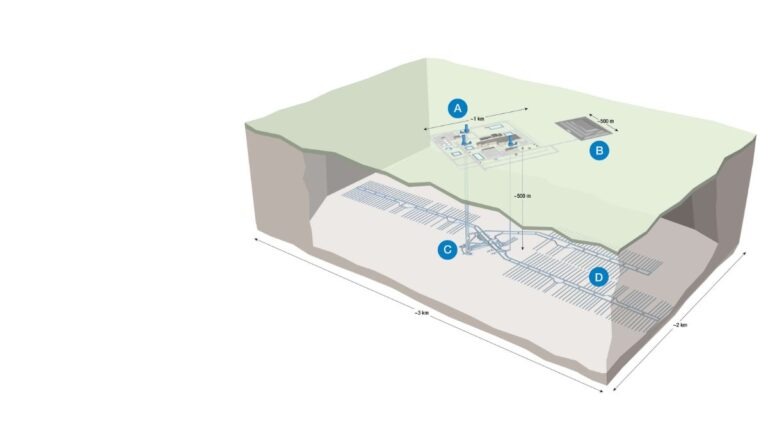
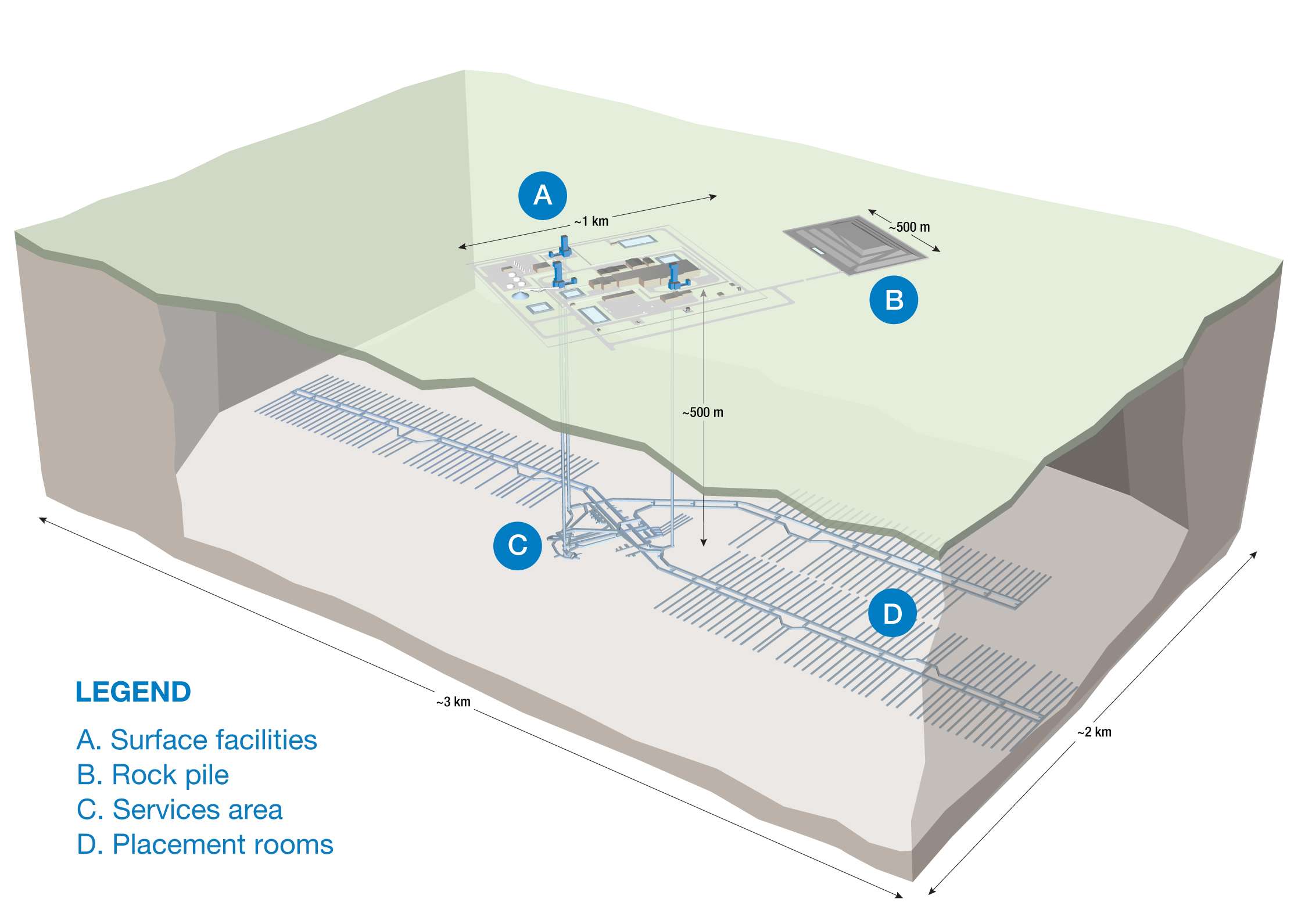
About the Deep Geological Repository (DGR) for Canada’s Used Nuclear Fuel Project
The Nuclear Waste Management Organization (the NWMO) is proposing a new underground deep geological repository system designed to safely contain and isolate used nuclear fuel. Wabigoon Lake Ojibway Nation (WLON) and the Township of Ignace have been selected as the host communities for the proposed project, which is located 21 kilometres southeast of the WLON and 43 kilometres northwest of the Town of Ignace, Ontario along Highway 17. As proposed, the Deep Geological Repository (DGR) for Canada’s Used Nuclear Fuel Project would provide permanent storage for approximately 5.9 million bundles of used nuclear fuel. The project is expected to span approximately 160 years, encompassing site preparation, construction, operation and closure monitoring. The project assessment is being conducted in collaboration with the Canadian Nuclear Safety Commission.
Learn more about the Integrated Impact Assessment process which is led by the Impact Assessment Agency of Canada and Canadian Nuclear Safety Commission.
- Read the Summary of Issues (February 16, 2026)
- Read the Summary of the Initial Project Description (January 5, 2026)
- Read the Initial Project Description (January 5, 2026)
- Learn More about the Melgund Integrated Nuclear Impact Assessment (MINIA) Project
- Learn More about the Nuclear Waste Management Organization (NWMO)